On a partly cloudy and mild (two digits!) day Jeff and I went out on the Two Canyon Loop, a hike in and around Lynn Creek and the Seymour River up in the North Shore mountains. This particular route provided some nice variety in the terrain, from comfortable straight stretches down alongside the Seymour Rive to steep ascents up stairs and rock to impressive views looking down into the Lynn Valley Canyon from several bridges, one of the suspension variety.
The Lynn Valley suspension bridge was host to a wedding party taking photos in the center of the span when we got there. The many people gathered on either side politely waited for them to finish, which didn’t take long, then proceeded to clog up the narrow span to the point where I got halfway across and gave up. That’s kind of like swimming halfway across a lake and deciding it’s too far, I know, but I hate crowds on narrow, bouncy spaces high above raging rivers. It’s just the way I am.
There was another bridge of the regular flat, non-swaying/bouncing variety earlier in the hike with a similar view. It was pretty much deserted.
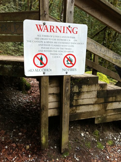
A short way past the suspension bridge is a pool that is apparently a popular, if dangerous, diving spot. This sign was posted nearby:
I am not sure why someone carefully excised the letters from ‘caution’ so it would read ‘urged to use extreme ca on’. It doesn’t even sound naughty. I do like that it warns the area has claimed many lives, not just one or two. Many. I guess a lot of people don’t read or the sign is recent. Or both. The no alcohol/fires part may as well be addressed, ‘Dear local teenagers’. Yes, I’m stereotyping but come on, you can picture it. A warm summer night, a bunch of drunk giddy kids skinnydipping and taking photos with their iPhones and simultaneously tweeting and, uh, Facebooking, about it:
LOL Dave is totaly naked lol and the water is SOOOOOO cold!!!!
OMG Dave hit his head diving some1 shuld call that 911 number!!!!
I think I here a bear and — (tweet ends here)
The staircase in that picture goes up an impressive ways. There’s a photo taken about halfway up in the gallery, located here.
The start of the hike took us along the Seymour River and through some areas that were used for mining back in the 1800s. There’s even a spooky old tunnel that was carved into a hillside for a pipeline. It’s kind of odd because the miners/loggers also built a two lane road (now the pedestrian trail) right next to it. Did curved piping not get invented until the 20th century or something? Maybe they had time to kill. At any rate, the tunnel was dark and spooky, as all old tunnels ought to be. We also came across an intriguing wooden archway that I imagined might lead to the lair of the Sasquatch or the site of strange forest rituals. It turned out to just be a short trail to the river.
The total time of the hike was about three hours and we took two breaks, the first under the powerlines, using the (modern) pipeline as a makeshift bench. To my consternation, there were mosquitoes about already. Then again, the place was also swarming with tourists, something else I hadn’t expected in late March. We dined on yummy dried apricots and trail mix all the same. When the sun came out it actually became too warm for three layers and we doffed our jackets. Near the end of the hike the sun hid away and it cooled enough for us to put the jackets back on. All hail the layering system!
We nearly took a wrong turn toward the end of the hike that would have added about 45 minutes to the trip but Jeff’s direction intuition kicked in and we asked a group about which way to head and they pointed us the right way. All hail those who know which way to go! Next time we’ll use the GPS.
This was a nice all-around trek, a perfect way to spend a few hours on a weekend afternoon.


