Average pace: 4:59/km
Location: Burnaby Lake, CCW
Distance: 11.93 km
Weather: Hazy sun, warm
Temp: 20ºC
Wind: light to none
Calories burned: 846
Total distance to date: 1450 km
I checked the Metro Vancouver Regional Parks web page before the run today and found an update regarding the blocked access on the Burnaby Lake trail. I quote:
Southshore Trail Closure
A portion of the Southshore Trail will be closed beginning June 18, 2012 for about two months to replace the boardwalk. During this time, the rest of the trail will remain open and visitors can complete the lake loop by using Freeway Trail. Access along Avalon Trail may occasionally be affected by construction equipment and vehicles. Visitors are reminded to follow posted detour and safety signs. For more information, call Metro Vancouver at 604-520-6442.
This is both good in that I know what is going on and bad because it means for two months I’m going to have to use the serviceable but generally unfun Freeway Trail detour until the new boardwalk is in place. I am curious to see what the new fancy boardwalk will look like, though. The old one didn’t seem to be in bad shape, thought it was a bit springy, which is probably not a good quality to have.
I knew today’s run was going to be more challenging with the warmer conditions. Since the weather keeps changing back and forth it’s difficult to adjust to the warmer days because there’s never enough of them to adjust to. Stupid June. Knowing I was unlikely to be setting a blistering pace, I set myself two goals: to run all three loops and try to come in under 5:00/km.
I finished with a pace of 4:59, completed all three loops and ended with a distance of 11:96 km. Since I never check distance before ending runs I didn’t realize I was so close to 12K. I would have pushed on for the smidgen extra had I known.
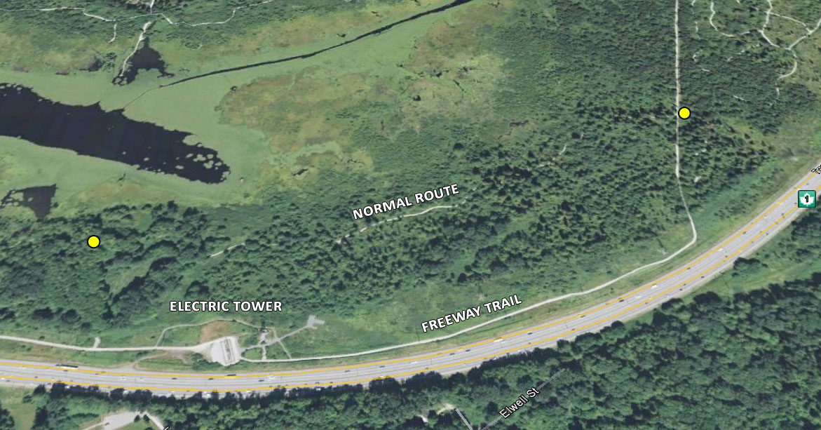
I ran counter-clockwise today so I didn’t get to the detour until I was past the 9K mark. I came in at 10K just as I passed the electrical tower. The Google maps image below shows the Freeway trail. I’ve highlighted where it connects to the parts of the run I normally take.
The hazy sun kept things tolerable but after a good start through the cooler woods of the northern trail I found my pace flagging some as I moved onto the more exposed southern side. Worse, the entire detour is completely exposed, though going CW the route is more downhill so it’s a little easier to manage.
My left foot started to complain around the 6K mark but eased up fairly quickly and was not a significant issue. I think it must change with the weather.
A solid, lengthy run overall. I think this will be the last time I use the same chart format.
Chart:
| km | Jun 20 | Jun 18 | Jun 16 | Jun 13 | Jun 11 | Jun 6 | Jun 4 | Jun 1 | May 30 |
|---|---|---|---|---|---|---|---|---|---|
| 1 | 4:31 | 4:29 | 4:34 | 4:35 | 4:34 | 4:37 | 4:37 | 4:42 | 4:37 |
| 2 | 4:40 | 4:43 | 4:45 | 4:48 | 4:47 | 4:45 | 4:42 | 4:46 | 4:45 |
| 3 | 4:48 | 4:41 | 4:50 | 4:54 | 4:56 | 4:49 | 4:45 | 4:49 | 4:48 |
| 4 | 4:54 | 4:50 | 4:52 | 4:51 | 4:57 | 4:51 | 4:47 | 4:51 | 4:49 |
| 5 | 4:56 | 4:51 | 4:51 | 4:50 | 5:03 | 4:49 | 4:49 | 4:51 | 4:50 |
| 6 | 4:57 | 4:53 | 4:48 | 4:49 | 5:01 | 4:49 | 4:51 | 4:52 | 4:50 |
| 7 | 5:01 | 4:54 | 4:54 | 4:51 | 5:07 | 4:51 | 4:52 | 4:53 | 4:51 |
| 8 | 5:07 | 4:55 | 4:56 | 4:55 | 5:10 | 4:54 | 4:53 | 4:54 | 4:52 |
| 9 | 5:11 | 4:55 | 4:54 | 4:58 | 5:14 | 4:53 | 4:53 | 4:55 | 4:52 |
| 10 | 5:13 | 4:54 | 4:58 | 4:57 | 5:15 | 4:52 | 4:54 | 4:56 | 4:53 |
| 11 | 5:13 | 4:52 | 4:52 | 4:58 | 5:09 | 4:45 | 4:54 | 4:56 | 4:52 |


