Danger! Fish! Hiking the Coquitlam River Trail

Today, with the weather forecast promising showers, we opted against Jeff’s planned trip to Dog Mountain, as it would take us up into the snow and snow with rain is one of the suckiest weather combos around. Instead, we headed over to the Coquitlam River Trail for a little under 3-hour hike. Unlike Baden-Powell, the river trail features little elevation gain and is relatively flat, so it was not as strenuous a workout, though I did pick up the pace a fair bit on our return.

With an overcast sky but mild temperatures, we set out sans jackets, with the plan to walk the trail to the point where one must ford the river. As it’s a bit deep this time of year and neither of us were carrying any portable watercraft, we would then reverse direction and head back the way we had come.

This was a nice, even relaxing hike. The trail at times moves far enough away from the river and any obvious signs of civilization to create the illusion that you are out there all on your own.  We actually never encountered anyone going in, only on the way back. The most distinctive part of the hike–apart from several large and ripe patches of skunk cabbage growing in pond water–were the numerous points where parts of the river crosses the trail. One especially big one (check the photo gallery for more) probably discourages the casual types from proceeding farther, especially at this time of year when non-waterproof footwear means cold and soggy feet. I was happy to just make it across without falling in.

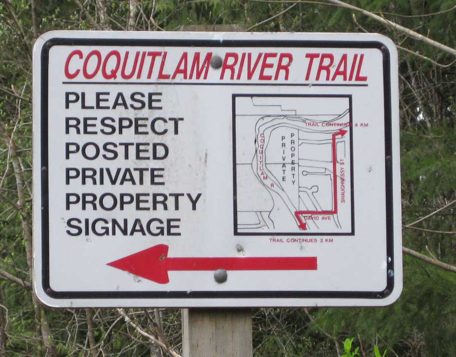
The red arrow on the sign is a bit confusing, as it points away from the trail but if you cast your eyes to the left there are no immediate private property signs that I could see, either, so I dunno. Mystery red arrow!

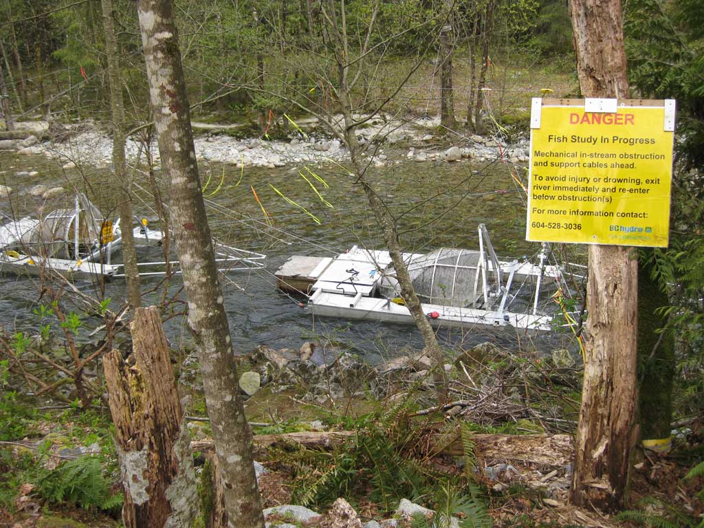
There are several fish traps near the start of the trail with big ol’ warning signs. This is part of a conservation effort, as the signs explained. I just like the incongruity of something as innocuous as ‘Fish Study in Progress’ being prefaced with DANGER.

We had some light snacks at the point where the river intersects the trail then stopped for lunch at Crystal Falls, where a mother/daughter biking duo and another group with a small dog were also taking pictures/resting. Jeff posed for a pic up close and personal with the waterfall and picked out his steps so carefully I could practically hear the calculations for each footstep in my mind.

As we got back to the truck the first few drops of rain began to fall, but the showers held off until we had packed everything up and headed out. All in all, a nice little excursion. The only downside was me apparently incubating a nasty flu bug the entire hike, which struck a couple of hours later. Weird how that sneaks up on you like some clever sneaky thing.

Gallery:

Couch to 5K: The Sequel, Part 3

Conditions were once again very mild for the run/walk today, with a weaker breeze and occasional sun. T-shirts and shorts were fine for the 10ºC or so.

The run was unremarkable. I jogged a bit ahead a few times on the 60 second running segments (which ramp up to 90 seconds next week), as the pace felt almost too slow for my comfort zone. Weird, I know.

This completes Week 1 of 9 for the Couch to 5K program. Jeff is progressing well, already moving from the initial “Oh god my lungs are on fire!” phase to “This feels pretty good.” We’ll see how things go on Monday!

Couch to 5K: The Sequel, Part 2

The second workout went well, with Jeff looking snazzy in his new running shoes and running faster through a combination of new shoes, music and endorphins. I also picked up the pace a bit on the running segments, falling more into my normal pace. No stupid injuries to report yet.

And today marked the first baseball practice taking place, as the clink of metal bat on ball was oft-heard while we jogged around the path. I have already begun watching the batters after the several close calls of the last two baseball seasons.

Weather-wise it was mostly overcast and a bit breezy but mild, otherwise. The fountain is working again and as usual has been stuffed so it isn’t draining properly. I may fix that if no one else does. Finally, I’m hoping the Parks Board puts some new mulch on the path as the past winter has been especially brutal on it, stripping it right down to the clay in some spots and exposing numerous tree roots (tripping hazards for joggers and walkers alike).  We shall see.

Onward to workout #3 on Friday!

Couch to 5K: The Sequel, Part 1

In which I join my partner as he goes from the couch to…5K.

Today was the first of the planned 27 outings and all went well at my old familiar haunt of China Creek Park. There were no bees in the fountain, no dogs getting under my feet and tripping me, no meteors suddenly crashing down from the sky. It was, in fact, sunny and mild (around 10ºC), if a bit breezy. We both lost something during the run. At the very start Jeff’s iPhone spontaneously detached itself and went tumbling to the ground. Fortunately he has it inside a plastic case designed to withstand the impact of a nuclear bomb, so it came out unscathed. The aforementioned wind whisked the cap off my head, forcing me to retreat to pick it up. Luckily it didn’t turn into one of those tragicomic episodes where the cap keeps getting rolled along the ground by the wind until it eventually ends up in traffic and smooshed by a series of 18 wheelers passing over it.

No official times/distances to report yet. This week’s workouts consist of alternating 90 seconds of jogging with 60 seconds of walking for 20 minutes. Here’s hoping I manage to avoid yet another injury while getting back up to speed.

Baden-Powell rocks (and sucks)

The best part of hiking the 2.5 hours we did on a segment of the Baden Powell trail today on the North Shore was probably the weather. It was the first time it’s been warm enough to go sans jackets. In fact, I could have worn shorts and been just as comfy.

The first half of the hike or so was fine, despite our primary destination being a place called Mosquito Creek. After 20 minutes or so I dubbed the path we were on The Snake as it was very undulating, winding left and right and also moving up and down regularly through gulleys, with relatively dense forest that afforded no real views (we did get to one near someone’s private residence that gave a decent view across to Vancouver). After crossing a large footbridge the trail shifted as it began to ascend along a narrow and rock-strewn path. In fact it was so narrow and rock-strewn that the constant looking down and carefully placement of my feet began to give me mild vertigo. As I have a sense of balance that would best be described as ‘not all there’ I felt fortunate not to plunge to my doom or at the very least stub a toe. We kept on for some time at a slow pace, picking our way among the roots and rocks. By the time we forded another stream by crossing a fallen log I was about ready to turn back. Fortunately I had to be home to feed the dog so I had a convenient excuse at the ready!

Here is the only picture taken on the hike — by Jeff, as I took none. The detail isn’t sufficient to really see the ‘Are we there yet?’ look on my face and looking at this, it occurs to me that a bright red shirt is probably the wrong color to be wearing as bears start coming out of hibernation.

All in all this was not a hike I’m eager to repeat, as too much of it felt more like climbing rather than hiking and I want to hike, darn it.


Here be tourists: The Two Canyon Loop hike

On a partly cloudy and mild (two digits!) day Jeff and I went out on the Two Canyon Loop, a hike in and around Lynn Creek and the Seymour River up in the North Shore mountains. This particular route provided some nice variety in the terrain, from comfortable straight stretches down alongside the Seymour Rive to steep ascents up stairs and rock to impressive views looking down into the Lynn Valley Canyon from several bridges, one of the suspension variety.

The Lynn Valley suspension bridge was host to a wedding party taking photos in the center of the span when we got there. The many people gathered on either side politely waited for them to finish, which didn’t take long, then proceeded to clog up the narrow span to the point where I got halfway across and gave up. That’s kind of like swimming halfway across a lake and deciding it’s too far, I know, but I hate crowds on narrow, bouncy spaces high above raging rivers. It’s just the way I am.

There was another bridge of the regular flat, non-swaying/bouncing variety earlier in the hike with a similar view. It was pretty much deserted.

A short way past the suspension bridge is a pool that is apparently a popular, if dangerous, diving spot. This sign was posted nearby:

I am not sure why someone carefully excised the letters from ‘caution’ so it would read ‘urged to use extreme ca on’. It doesn’t even sound naughty. I do like that it warns the area has claimed many lives, not just one or two. Many. I guess a lot of people don’t read or the sign is recent. Or both. The no alcohol/fires part may as well be addressed, ‘Dear local teenagers’. Yes, I’m stereotyping but come on, you can picture it. A warm summer night, a bunch of drunk giddy kids skinnydipping and taking photos with their iPhones and simultaneously tweeting and, uh, Facebooking, about it:

LOL Dave is totaly naked lol and the water is SOOOOOO cold!!!!

OMG Dave hit his head diving some1 shuld call that 911 number!!!!

I think I here a bear and — (tweet ends here)

The staircase in that picture goes up an impressive ways. There’s a photo taken about halfway up in the gallery, located here.

The start of the hike took us along the Seymour River and through some areas that were used for mining back in the 1800s. There’s even a spooky old tunnel that was carved into a hillside for a pipeline. It’s kind of odd because the miners/loggers also built a two lane road (now the pedestrian trail) right next to it. Did curved piping not get invented until the 20th century or something? Maybe they had time to kill. At any rate, the tunnel was dark and spooky, as all old tunnels ought to be. We also came across an intriguing wooden archway that I imagined might lead to the lair of the Sasquatch or the site of strange forest rituals. It turned out to just be a short trail to the river.

The total time of the hike was about three hours and we took two breaks, the first under the powerlines, using the (modern) pipeline as a makeshift bench. To my consternation, there were mosquitoes about already. Then again, the place was also swarming with tourists, something else I hadn’t expected in late March. We dined on yummy dried apricots and trail mix all the same. When the sun came out it actually became too warm for three layers and we doffed our jackets. Near the end of the hike the sun hid away and it cooled enough for us to put the jackets back on. All hail the layering system!

We nearly took a wrong turn toward the end of the hike that would have added about 45 minutes to the trip but Jeff’s direction intuition kicked in and we asked a group about which way to head and they pointed us the right way. All hail those who know which way to go! Next time we’ll use the GPS.

This was a nice all-around trek, a perfect way to spend a few hours on a weekend afternoon.

Two Valley Loop photo gallery

Back to the Future 26 years later: It still works

I watched Back to the Future today for the first time in many years, and it still holds up well. The cast, anchored by the amazingly weird Crispin Glover, is terrific, and the story puts all the pieces together surprisingly well for a time travel plot. It helps that it’s a comedy and the science fiction stuff can be hand-waved as needed (more so than normal).

The cutest part, of course, is how quaint the present-day setting of 1985 looks now. Michael J. Fox wears suspenders without irony. The women have hair that towers like skyscrapers. Music is played on cassettes!

Definitely worth catching again if it happens to be on TV.

Brothers Creek -or- The wrong way to avoid snow

Today’s hike started around mid-morning and though we didn’t keep accurate track of the time it took approximately three hours in total.

With the destination chosen just minutes before leaving, we headed out to Brothers Creek on the North Shore. Following a hiker’s directions printed off from trailpeak.com we made our way to the entrance, already a fair way up the mountain. With a million dollar home sitting just below where the truck was parked, we headed past a giant sign erected by British Pacific Properties Ltd that essentially said “If you go past this gate and something bad happens to you, you promise never to sue us. If it’s clearly our fault, it’s still your fault. No suing allowed!”

The million dollar home had a thin layer of snow across its luxuriously-appointed patio, so our plans to avoid all snow on hikes seemed less than promising. The weather, on the other hand, was spectacular, with clear skies and temperatures hovering just below freezing.

The trail starts out as an emergency access road and as it continues upward through a number of switchbacks it narrows and becomes more of a regular hiking trail. The walking stick was definitely seeing some use here. The snow was thin and in patches to start and in some spots it was easier to actually walk on it rather than navigate across the icier bits of the path. As we continued to ascend the ratio of snow to exposed ground grew until we were up to our knees and in a few spots even deeper.

It is telling that the first four people we met (all on the way back, as there was not a soul up ahead of us) had snowshoes.

When we reached Brothers Creek itself the snow was piled up on the bridge above the railings. We elected to not continue on the loop that may or may not have taken us back to where the truck was parked and instead chose to take the 1.67 km detour off to a lake up yonder. It was here that we noticed the only real tracks in the snow were from snowshoes. We pressed on, the trail completely covered under deep snow, with only occasional markers on the trees serving as reliable guides. We came to a bridge of sorts. It was difficult to tell what it might have looked like in warmer months but now it was a tall and very narrow snow-covered line, with a cone-shaped hole in the snow leading down to icy water on one side and, well, just plain old icy water on the other. I talked Jeff into going first.

A little farther on we came to a point where it looked like our snowshoeing adventurer had some trouble determining where the trail was. Rather than crossing at the actual bridge over the creek here he had chosen to make his way on a loop along the edge of the creek and then cross through some brambles at a point where the creek narrowed. We spotted the bridge a ways to the southeast. It was very low and nearly obliterated under what was at least two meters of snow. Like the previous snow bridge, this one was very narrow but with the added bonus of not reaching all the way across, necessitating a small jump. Again, I volunteered Jeff to go first. I followed after, opting to use an extended walking stick from him to help complete the last step.

After making our way across the creek we found the snowshoe tracks came to an end. The actual trail, probably 10 meters or so away, was buried under virgin snow. We looked at our snowshoe-less feet and decided to turn back.

On the way back I totally psyched myself on the jump by spending way too much time thinking about it. I eventually made it, as the detour around it was too long. Convenience conquers fear!

We stopped at Lost Lake to have a stand-up lunch (nowhere to sit in those huge drifts of snow). Lost Lake was truly lost — completely buried under a thick blanket of snow. I forgot to take a picture. Oh well.

The return trip had us pass by three couples — a young man and woman with snowshoes, a couple of older men also with snowshoes and a pair of Australians, one of whom was wearing a t-shirt and shorts. He asked if there would be any ‘bairs’. We assured him that they were all too smart to come out in all this silly snow like us humans. The final group we met back at the entrance, a young threesome. One woman excitedly asked us if there was much snow up higher. When we replied that there was indeed snow aplenty she seemed positively delighted. Could not have been a local.

While it was a bit disappointing that we couldn’t complete the loop or get to the lake up top, it was still a great hike, with nearly perfect weather, some majestic old growth forest and a beautiful blanket of snow covering it all.

For reference, here’s the bridge at Brother’s Creek as seen in the summer:

And here’s what it looked like when we got to it:

Full gallery.


The long (and short) road back

Today was my first run on a workday. Woo!

It was also a very brief run, only 2.5 km after a three week layoff. It was about 7ºC, overcast with some light rain. I wore a jacket and long-sleeve t-shirt and may have been okay with just the t-shirt as the wind died down just prior to the run.

Some notes:

• I was recovering from the effects of some bug (felt kind of like the flu, sucked all my energy away for a couple days like some kind of sparkly vampire in germ form)
• the conditions were the worst I’ve ever seen. Many stretches of the trail were little more than mire and multiple times I felt my foot twisting on the uneven surface. A lot of exposed roots, too, as the continued heavy rains strip away the surface.
• annoying jogger duo. A pair of women were jogging ahead of me and stopped at the playground. They were apparently doing a start-stop thing. A little ways after passing them they resumed running and kept pace a modest distance behind me. No big deal. Except one of them would not stop yakking.It made me crazy. On the one hand, if you can carry on an (incessant) conversation while jogging, you aren’t trying hard enough. On the other hand, if I was in better condition I could have easily outpaced them and gotten out of hearing range, so I also suck. I am hoping to remedy this by running again on Friday with a ‘run as far as I feel comfortable’ plan (up to 10K). We’ll see how it goes.

No official™ chart for this run because it was such a quickie but here are the relevant stats:

1km = 5:10
2 km = 5:23 (yuck)

Total average pace: 5.28.

Long lines and the price of McFreedom

The other morning I was in the food court near where I work and, as is usually the case at this time of day, there weren’t many people milling about. Then I espied a line-up that was not merely long, but downright lengthy in extreme.

It turned out it was for McDonald’s, as they had just introduced new buttermilk biscuits as part of their breakfast menu and for two days they were offering them for free.

Free, as it turns out, is a popular price.

Here’s some of what these people got for free by opting for the Sausage ‘n Egg Biscuit Sandwich:

48% of your daily sodium (1140 mg)
57% of your daily fat (37 g)
590 calories
240 mg cholesterol
19 grams protein
30% of your daily iron

So you’ll simultaneously get fat, clog your arteries, increase your blood pressure but also gain a tiny bit of muscle (under the fat). Seems like a good deal. It’s hard to figure out why so many people are obese. Really!

(Disclaimer: Occasional fast food is a welcome indulgence for those who like it. I am eating whole grain tortilla chips and fresh salsa as I type this.)

Buntzen Lake or A Bridge Too Far (Submerged)

The forecast for today was for rain and rain it did. Regardless, a little damp weather was not going to stop us from spending the afternoon hiking around the entirety of Buntzen Lake.

Because of high water some trails were closed and numerous signs warned us to add 2-3 hours to our trek. We arrived at 10:30 a.m. and the gate to the park is locked at 5 p.m. so we were confident that with the 5-7 hour total estimate we’d be out long before we got locked in with the squirrels and monsters (for the record, I didn’t actually see any squirrels or monsters, though someone was walking a toy dog dressed in a pink raincoat bright enough to serve as a beacon.

We parked in the northern-most parking lot and started north along the east side of the lake, heading up a service road as the first section of trail on this side was closed due to the high water. We then hit the cleverly-named Buntzen Lake Trail proper (it just occurred to me that the acronym is BLT — mmm, BLT) and stayed on it to the suspension bridge at the north end of the lake (less than a meter above the water at this time of year). A short way past the bridge the trail turns back south and splits, with delicious BLT on the left and Lakeview Trail heading up and to the right. As you can see in the close-up shot below, our decision at this junction was easy as the Buntzen Lake Trail was completely submerged. Up the ridge we went!

There were a few steep sections on the Lakeview Trail but I didn’t regret passing on the walking stick this time. We reached the one official lookout about halfway through our trek and stopped for a snack and some water. This gave us the best view of the lake, with low cloud scudding through the valley as the rain continued to pour steadily. Speaking of the rain, we passed someone carrying an umbrella. That seems a bit silly, especially considering how steep the climb gets in a few spots, not to mention that it’s very difficult to escape getting your feet covered in muck and mire, so it’s not like an umbrella is going to keep you clean and dry out here. As proof, I planted my foot in one especially juicy section of mud and it was rather intent on keeping the boot for itself. I managed to wiggle the boot free, cherishing my triumph over nature as I did so.

We eventually reached what would have been near to the end of the hike at the floating bridge, but it too was closed due to that whole being-completely-underwater thing. This forced us to extend our hike around the southern tip of the lake, around and up to Academy Trail before we eventually reconnected to the parking lot we started from.

Our total time ended up being a fairly brisk 3 hours and 10 minutes. I spent the time saved soaking in the tub back at the condo.

Overall it was a good hike. There were a few more people out braving the rain than I had expected and a few times we caught up to others ahead of us and I felt that ol’ ‘gotta pass’ thing kick in. I swear I am not a competitive person by nature!

Clothing-wise, the two weak points for me were my baseball cap, which was okay at keeping my head dry but didn’t fit snugly, forcing me to constantly re-adjust it. This led to a slight rash on my forehead. Nothing major, but annoying. I need a hiking hat. My gloves became soaked about 2/3 of the way through, leaving my fingers a bit cold for the last hour or thereabouts, so I’m definitely going to look for a water-resistant/inner layer glove system for future treks.

Note for future hikes: Do not let Jeff carry the potato chips, as he apparently keeps them secured under rocks. 😛

Our route below starts at the northern parking lot and follows the service road to where the first viewpoint is on #4 (Buntzen Lake Trail). We stayed on #4 past the suspension bridge before switching to #8 (Lakeview Trail). We stayed on #8 until we crossed the road south of the lake and headed back up #9 (Academy Trail). Here’s the full PDF map file on BC Hydro’s website and the page the map is linked from here.

Buntzen Lake Trail Tour 2011
Sponsored by Jack Johnson (well, he was playing on the iPod in the truck, anyway)

And some photos of the hike.

Return to the Valley of the Jogger: The Sequel

And unlike many sequels, this one is actually better than the first!

Conditions for my second run after the long layoff were decent. The temperature was 7ºC with little wind and an overcast sky. I wore a long-sleeved t-shirt and shorts and probably would have been fine with a regular t-shirt. My hands did not feel like frozen blocks of ice this time.

There was a hard, steady rain yesterday and the trail at the park showed the effects — several large puddles to be dodged, the southern stretch particularly boggy in several places and more exposed roots poking through than I’ve ever seen. I did a walk around first to size things up before the run proper.

By the second km I was feeling a cramp but this time in my stomach. I maintained my pace and within another km or so it eased up, allowing me to better hold my pace. I was faster at each stage of the run than a week ago and finished by shaving seven seconds off last week’s run, bringing my pace down from 5:44 to 5:37. Not bad!

I could feel my left knee a bit during the run but it never hurt and didn’t slow me down. For a few moments there was a twinge around my ankle/lower left shin and that spooked me but it went away quickly and did not return.

Although my performance was better, the improved pace meant that by the time I hit 5K I was happy to stop and recover rather than feeling all, “Haha, whee! Let’s keep going!” That’s okay. In time my stamina will be back where it once was and I shall run not unlike the wind. Or at least a strong breeze.

Chart:

km Jan. 25 Jan 18
1 km 5:04 5:07
2 km 5:20 5:26
3 km 5:31 5:36
4 km 5:36 5:42
5 km 5:37 5:44