Why does Google Maps hate New Westminster?

I’m about to do something I’ve never done before: Defend Bing Maps. And Apple Maps.

Background

In 2017 the Royal Columbian Hospital, which I live next door to, began Phase 1 of a huge redevelopment project. This first phase was to replace an outdoor parking lot with a new Mental Health and Substance Use Wellness Centre. Or what they used to call insane asylums/funny farms, and drug addiction rehab.

Anyway, the building was completed in late 2019 and opened in early 2020.

In 2021, the next phase began, the construction of a new acute care tower that is monstrously huge compared to the existing tower. This is due to be complete in 2025, with the building exterior slated to be done by the end of 2023.

The maps compared

This is the Google Maps satellite view of the area.

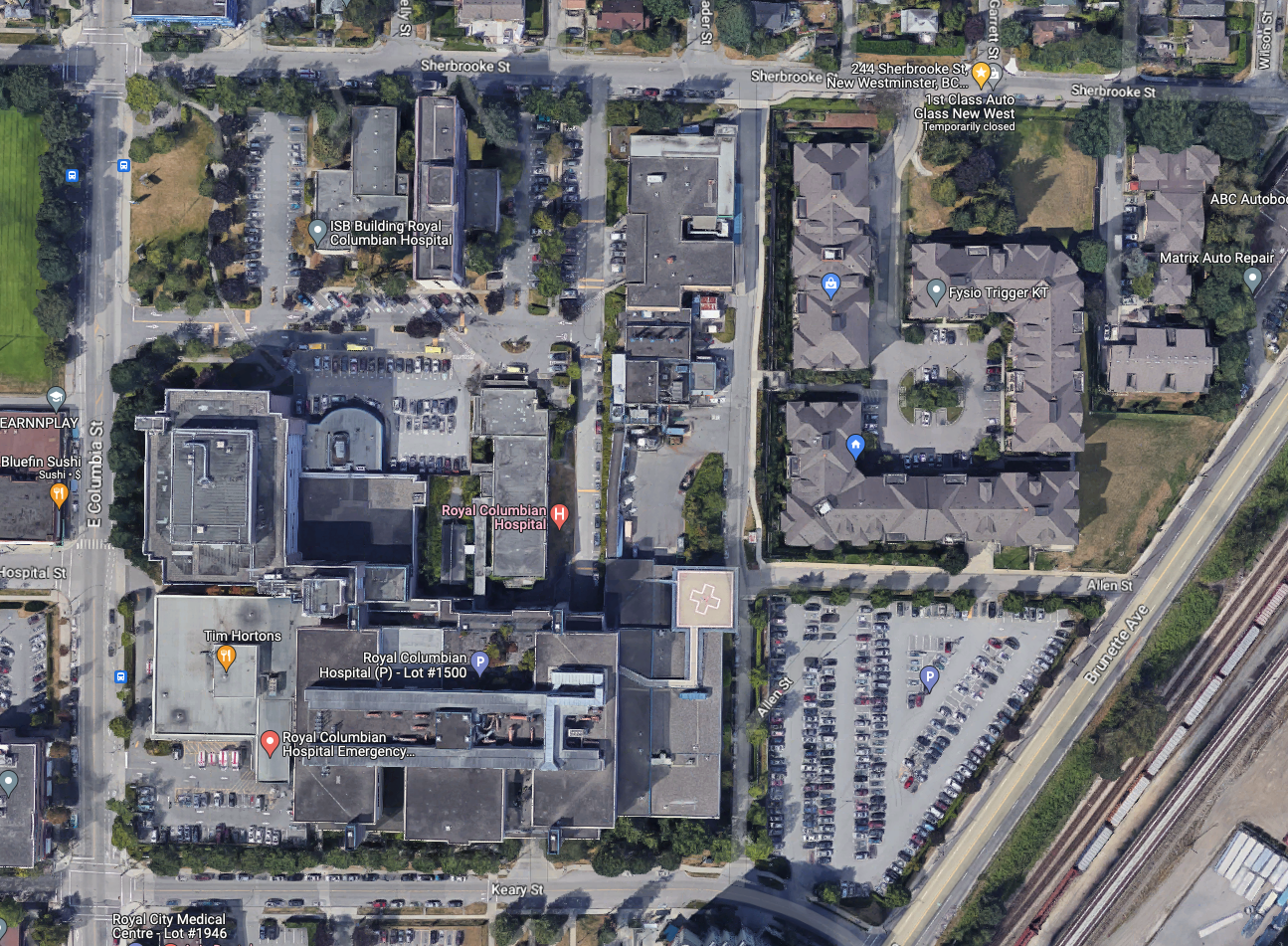
As you can see, Google Maps:

  • Still shows the parking lot that hasn’t existed since 2017 (lower right corner)
  • Still shows the Sherbrooke Centre (upper left), electrical building and shipping/receiving area of RCH (centre top), which are now gone, the former being demolished more than a year ago.

And the Bing Maps view below.
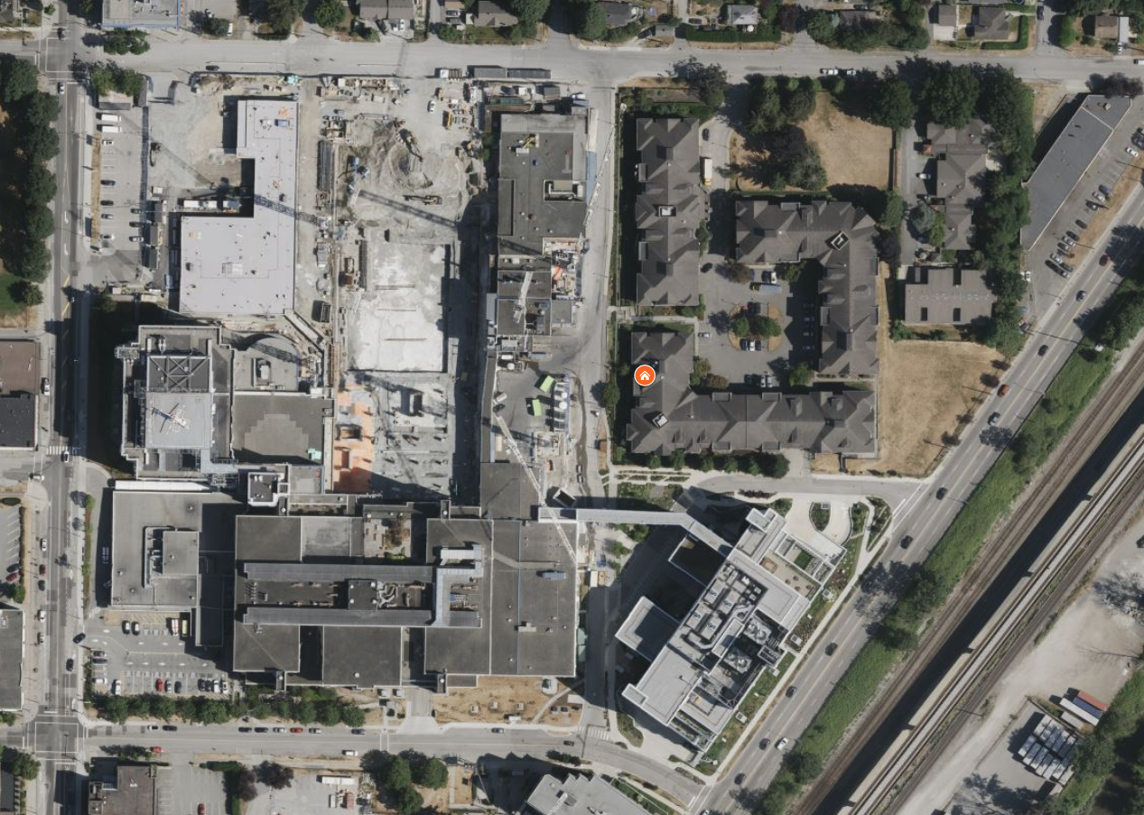
Bing Maps:

  • Correctly show the new Mental Health building (lower right)
  • Correctly shows the Phase 2 acute tower construction underway (centre top)
  • Correctly shows the temporary shipping/receiving building in the northwest corner (top left)

The only issue here is it’s a bit out of date, as the electrical and shipping/receiving buildings are still present and have since been demolished–though to be fair, the last of the old shipping/receiving building only came down in the last month.

Bonus round: Apple Maps

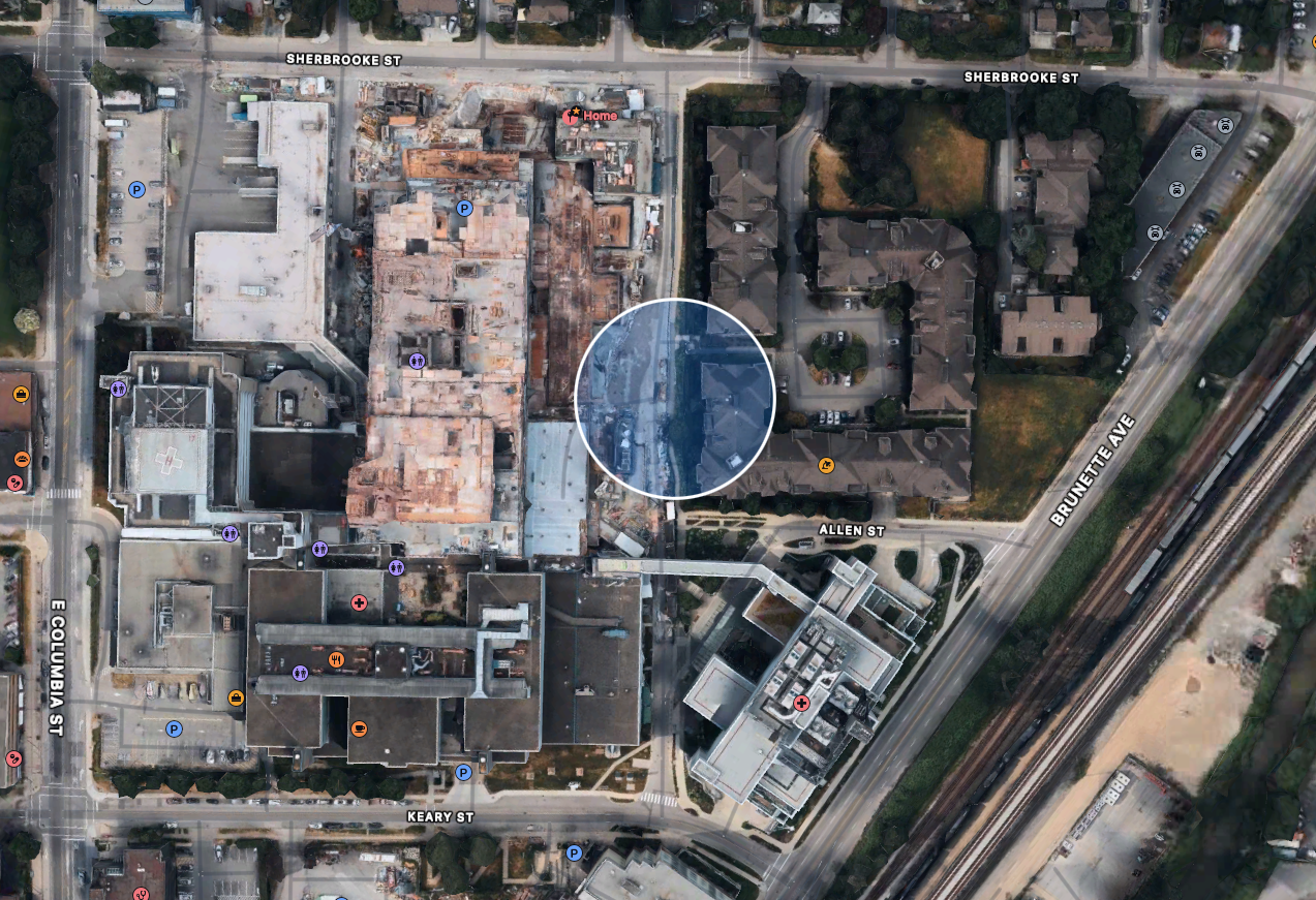
If you happen to have an Apple device, you can also use Apple Maps. The screenshot above is from the Mac version. It:

  • Correctly show the new Mental Health building (lower right)
  • Correctly shows the Phase 2 acute tower construction underway (centre top)
  • Correctly shows the temporary shipping/receiving building in the northwest corner (top left)
  • Bonus: Shows further progress in the construction, including only the corner remaining of the old shipping/receiving building, which was only demolished a month ago (March 2023)

Gallery showing all three maps views:

Conclusion:

For reasons unknown, Google considers New Westminster to be too piddly to warrant anything resembling an accurate satellite view, while Microsoft doesn’t. Now, Google does have a street view of the same area, and it is as recent as May 2022, so just under a year old. Microsoft only has the equivalent for parts of Vancouver, and nothing for New Westminster. Apples does have a street view equivalent of Google, but it appears to be older than Google’s.

Winners:

  • Apple for most current satellite view
  • Google for most current street view

Runner-up:

  • Microsoft for having a reasonably current satellite view

Losers:

  • Google for having a hideously old satellite view
  • Microsoft for not having any street view

Overall, I’d have to give Apple the edge, as satellite view is the most important (IMO) and their street view a) exists and b) is reasonably up-to-date. If you don’t need a street view, Microsoft is a solid second place choice. Google needs to divert some of its ad billions to updating its imagery more than once per decade.

Possibly made internet famous on an app I never use

The other day Jeff and I were returning from Save On Foods, carrying bags of groceries and walking along the mind of awful Brunette Avenue, where people drive at highway speeds (it is not a highway). I happened to notice one of the vehicles that blew past (actually, it was probably doing the speed limit) was an Apple Maps car. I’ve never seen one out in the wild before.

Now, I never use the Apple Maps app on my iPhone. It had a disastrous launch and I’ve never had a reason to go back and check the improved version, since Google Maps still works fine. But now I am officially part of an Apple Map. My face will be blurred out, but every time I check out a map of my neighborhood, there I will be. I’ll be internet famous!

The shiny new version of Apple Maps isn’t out yet, though. It’s coming in the next release of iOS, macOS, iPadOS and WhateverElseOS Apple comes out with. This should happen in September. I’l check back then, as that is when their version of Google’s Street View, called “Look around” (Apple is very bad at names) debuts. I’ll report back then and will sign autographs shortly after.

How to not be eaten by a grue, as revealed by me 26 years ago

I’d like to say I grew up on text adventure games, even though that would identify me as olde, but in reality the genre was already well-developed when I was in my teens. Still, I fondly recall getting nearly all of the Infocom games for my Commodore 64, during the period between 1984 and 1988. By 1989 the market had shifted, Infocom was making games with actual graphics and the text adventure pretty much died. It would be many years before freely-available interpreters and languages for writing text adventures would lead to a minor renaissance of the genre.

You can find information about a lot of the resultant games and more at The Interactive Fiction Archive.

Information on Infocom games can be found at Infocom – The Master Storytellers (and, of course, Wikipedia).

A text adventure was simple to learn–type your actions at a command prompt, read the results, repeat until you have solved all the puzzles in the game–but often the biggest puzzle was figuring out which words or commands the game could understand and the proper way to present them.

Back in that mid-80s era when computer graphics were less sophisticated (ie, crude, terrible) I spent many hours working through Infocom’s games. This was also my first bit of co-op gaming as I usually had a friend assisting me. Two brains will theoretically solve puzzles more capably than one. Until both brains get completely stuck, that is. That’s when you mail order the Invisiclues hint book and wait weeks to finally get an answer. It was the gaming equivalent of walking to school uphill in the snow both ways. And we liked it!

One of the key requirements of playing an Infocom game was making a map. Sure, you could try memorizing the game world and with some simpler titles it might even work, but making a map was essential for nearly all Infocom games. I’m fairly certain that utter madness was the only reward for successfully mapping out all of Zork I and its mazes.

I took to making most of my maps in a sketchbook and recently scanned in some of the more detailed maps. By the end I think I was playing the games more to make the maps than to play the actual games. Going back and looking through the maps also made me realize there are more than a few of these games that I left unfinished. Now they taunt me and I consider re-playing them using programs like Gargoyle or Windows Frotz to help make the experience more pleasurable than those halcyon days of yore with my Commodore 64 displaying 40 whole characters of text on a single line. 40! And I always knew I had successfully solved a puzzle because the 1541 disk drive would start grinding away madly to fetch a new chunk of game. Today I can use Trizbort to automate the mapping process entirely but I know if I do go back I’ll have that sketchbook at hand and start doodling again because it was part of the magic.

And a game without magic is just a game.

Here are the maps I’ve scanned so far.

First up is Zork I. The maze in this game (twisty passages, all alike) requires you to drop items in order to successfully map it out. Following all of these lines still gives me a headache. I never finished the game but I did finish the maze!

Next is Infidel, featuring ASCII hieroglyphics and even a start and end date for the game playthrough. How nerdy.

I have two Enchanter maps, the first image being from the start of the game and the second being the next area. I like the turtle.

And the follow-up area:

Finally the maps for Spellbreaker even includes 3D shading. Fancy!